Earth Embeddings and Geospatial Representation Learning
Learning general-purpose representations that capture spatial, temporal, and contextual signals across Earth.
Embeddings, explained simply
An embedding is a short list of numbers that acts like a fingerprint for something complex (an image, text, or a place). Similar fingerprints mean similar content-enabling fast search, grouping, and prediction.
Key papers and main takeaways
Earth Embeddings: Toward AI-centric Representations of our Planet (IEEE Geoscience and Remote Sensing Magazine — Perspective, 2025)
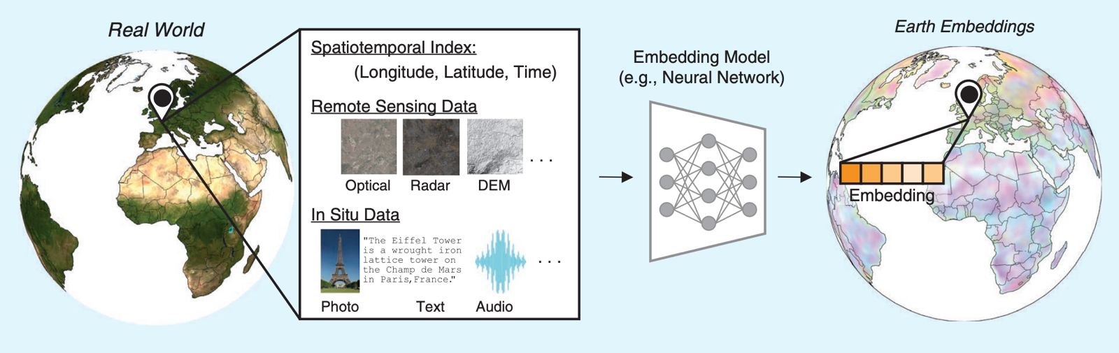
We argue that Earth Embeddings represent the next abstraction layer for geospatial AI: shared representations of our planet learned from satellite imagery, maps, elevation, climate, and other geospatial data — with the potential to become a fundamental building block of next-generation Earth observation models.
Main contributions:
- Categorizes Earth embeddings as datasets and models, spanning implicit and explicit representations.
- Identifies four core functions of Earth embeddings across retrieval, generalization, fusion, and diagnostics.
- Draws parallels between geospatial and language embeddings, motivating Earth embeddings as a first-class abstraction.
- Outlines a roadmap and calls to action for the geospatial AI community.
Also available as preprint: EarthArXiv
SatCLIP: Global, General-Purpose Location Embeddings with Satellite Imagery
- Proposes contrastive pretraining that matches satellite image features with their geographic coordinates to learn a location encoder.
- Produces general-purpose location embeddings that transfer across many downstream tasks and improve geographic generalization.
- Shows that geolocalized EO imagery can act as scalable supervision for learning “place representations” without dense labels.
Geographic Location Encoding with Spherical Harmonics and Sinusoidal Representation Networks
- Highlights why global location encoding is tricky: naïve coordinate embeddings can create spherical artifacts (notably near the poles).
- Introduces a principled global encoder combining spherical harmonics (sphere-native basis) with sinusoidal representation networks (SIREN).
- Demonstrates strong performance across benchmarks, motivating INRs/location encoders as a foundation for global Earth representations.
Measuring the Intrinsic Dimension of Earth Representations
- Studies intrinsic dimension as a label-free lens on “how much information” Earth representations actually use (vs. their ambient vector size).
- Finds intrinsic dimension is often much smaller than the embedding size and varies with resolution and training modality.
- Shows intrinsic dimension can correlate with downstream performance and reveal spatial artifacts, supporting diagnostics and model selection.
Where we are heading
We build Earth embeddings to enable:
- global retrieval (“find places like this”),
- robust transfer across regions and sensors,
- multimodal fusion (EO, climate, maps, text),
- and interpretable representations with diagnostics that help scientific trust and use.