Research
Research Topics
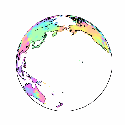
Earth Embeddings and Geospatial Representation Learning
2023 - ongoing
Learning general-purpose representations that capture spatial, temporal, and contextual signals across Earth observation data.
Learn More
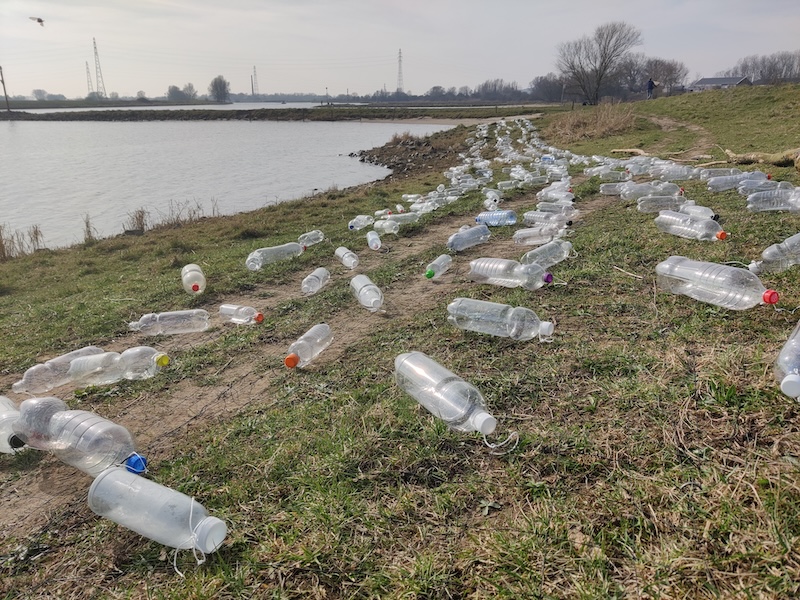
Marine Litter Monitoring with Remote Sensing and AI Models
2021 - ongoing
Detecting and tracking marine debris from multi-sensor imagery to support monitoring and response.
Learn More

Few-Shot Meta-Learning and Transfer Learning
2020 - 2023
Designing models that adapt quickly to new regions, sensors, and tasks with minimal labeled data.
Learn More
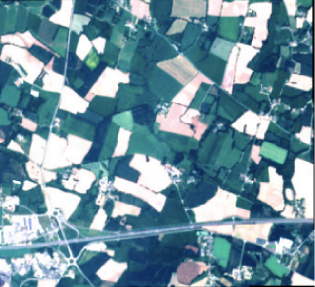
Large-scale Crop Type Mapping with Deep Time Series Classifiers
2018 - 2021
Scalable crop-type mapping from Sentinel time series, with models that generalize across regions and can deliver reliable in-season predictions.
Learn More
Publications
- Better Together: Evaluating The Complementarity Of Earth Embedding Models — arXiv (Cornell University) (2026)
- Dataset Underlying The Publication "Detecting Marine Litter Windrows In PlanetScope Imagery" — Zenodo (Dataset Contribution) (2026)
- Exploring Transferability Of Plastic-Water Hyacinth Interaction And Detection In Rivers — Accepted at Cell iScience (2026)
- Exploring Plastic Detectability On Riverbanks Using Remote Sensing — Accepted at Marine Pollution Bulletin (2026)
- Localized, High-Resolution Geographic Representations With Slepian Functions — Accepted at the International Conference in Machine Learning (ICML, 2026)
- Sentinel-2 Reveals Prolonged And Localized Extreme Vegetation Anomalies Across Europe — SSRN (Preprint, 2026)
- Self-Supervised Pre-Training Enables Marine Debris Detection Across Sensors — Remote Sensing of Environment (2026)
- Measuring The Intrinsic Dimension Of Earth Representations — Accepted to ICLR 2026
- NaT-ReX: Naturalness Assessment With Transformer-Based Reliable Explainability — Pattern Recognition - 47th DAGM German Conference on Pattern Recognition (GCPR 2025), LNCS 16125, pp. 571-585
- River Plastic Hotspot Detection From Space — iScience, 29(2), article 114570 (2025)
- Earth Embeddings: Towards AI-Centric Representations Of Our Planet — EarthArXiv (Preprint) (2025)
- On The Added Value Of Sequential Deep Learning For The Upscaling Of Evapotranspiration — Biogeosciences (2025)
- Earth Embeddings: Harnessing The Information In Earth Observation Data With Machine Learning — Abstract (talk E. Rolf) (2025)
- From General To Specialized: The Need For Foundational Models In Agriculture — SEA Workshop on Sustainability with Earth Observation and AI at ICCV 2025
- SatCLIP: Global, General-Purpose Location Embeddings With Satellite Imagery — Proceedings of the AAAI Conference on Artificial Intelligence, 39(4), pp. 4347-4355 (2025)
- Autoregressive Denoising Diffusion For Predicting Trajectories Of Floating Objects In Oceans — In Review - Major Revision IOPScience MLEarth (2025)
- A Cross-Sensor Approach For Marine Litter Detection With Self-Supervised Learning — EGU Abstract (2025)
- AirCast: Improving Air Pollution Forecasting Through Multi-Variable Data Alignment — Proceedings of the TerraBytes ICML Workshop, PMLR 292, pp. 46-62. Best Workshop Paper Award (2025)
- Time, Space, Or Both? A Comparison Of Flexible Spatio-Temporal Deep Learning Architectures To Map Tree Cover Loss From Sentinel-2 Data — SSRN Electronic Journal (2025)
- Scalable Classification Of Riverine Plastic Hotspots Using Sentinel-2 And Cloud-Based Machine Learning — Cell iScience (2025)
- SAMSelect: A Spectral Index Search For Marine Debris Visualization Using Segment Anything — IEEE Geoscience and Remote Sensing Letters, 22, pp. 1-5 (2025)
- Deep Pre-Trained Time Series Features For Tree Species Classification In The Dutch Forest Inventory — SSRN Electronic Journal (2025)
- Better, Not Just More: Data-Centric Machine Learning For Earth Observation — IEEE Geoscience and Remote Sensing Magazine, 12(4), pp. 335-355 (2024)
- On The Added Value Of Sequential Deep Learning For Upscaling Evapotranspiration — (2024)
- Mapping Drivers Of Tropical Forest Loss With Satellite Image Time Series And Machine Learning — Environmental Research Letters (2024)
- WildCLIP: Scene And Animal Attribute Retrieval From Camera Trap Data With Domain-Adapted Vision-Language Models — International Journal of Computer Vision (2024)
- Spatially Far, Ecologically Close: Evaluating Extrapolation On Vegetation Forecasting Models — Machine Learning for Remote Sensing Workshop at ICLR 2024
- Multi-Temporal Forest Monitoring In The Swiss Alps With Knowledge-Guided Deep Learning — Remote Sensing of Environment (2024)
- Imbalance-Aware Presence-Only Loss Function For Species Distribution Modeling — Tackling Climate Change with Machine Learning at ICLR Workshop 2024
- Analyzing Spatio-Temporal Machine Learning Models Through Input Perturbation — (2024)
- Linking Deep Learning-Based Forest Cover Maps To Treeline Spatio-Temporal Patterns — (2024)
- Where The White Continent Is Blue: Deep Learning Locates Bare Ice In Antarctica — Geophysical Research Letters (2024)
- Datasets For "Where The White Continent Is Blue: Deep Learning Locates Bare Ice In Antarctica" — Zenodo (CERN European Organization for Nuclear Research) (2024)
- Geographic Location Encoding With Spherical Harmonics And Sinusoidal Representation Networks — International Conference on Learning Representations (ICLR 2024), Spotlight
- Meta-Learning To Address Diverse Earth Observation Problems Across Resolutions — Communications Earth & Environment (2024)
- Large-Scale Detection Of Marine Debris In Coastal Areas With Sentinel-2 — iScience (2023)
- Semi-Supervised Deep Learning Representations In Earth Observation Based Forest Management — (2023)
- Improving Few-Shot Object Detection With Object Part Proposals — (2023)
- Detection Of Settlements In Tanzania And Mozambique By Many Regional Few-Shot Models — (2023)
- Classification Of Tropical Deforestation Drivers With Machine Learning And Satellite Image Time Series — (2023)
- Short-Term Runoff Forecasting In An Alpine Catchment With A Long Short-Term Memory Neural Network — Frontiers in Water (2023)
- Improved Marine Debris Detection In Satellite Imagery With Automatic Refinement Of Coarse Hand Annotations — Machine Learning for Remote Sensing Workshop at ICLR 2023
- Mapping Forest Cover Dynamics In The Swiss Alps Using 70 Years Of Aerial Imagery — (2023)
- A New Blue Ice Area Map Of Antarctica — (2023)
- End-To-End Learned Early Classification Of Time Series For In-Season Crop Type Mapping — ISPRS Journal of Photogrammetry and Remote Sensing (2023)
- Instance Norm Improves Meta-Learning In Class-Imbalanced Land Cover Classification — NeurIPS 2022 Workshop
- Humans Are Poor Few-Shot Classifiers For Sentinel-2 Land Cover — IGARSS 2022 - 2022 IEEE International Geoscience and Remote Sensing Symposium
- What Determines The Location Of Antarctic Blue Ice Areas? A Deep Learning Approach — (2022)
- Data-Driven Feature Learning With Discriminative Models For Satellite Time Series — Doctoral dissertation, Technische Universität München (2022)
- Time Dependent Image Generation Of Plants From Incomplete Sequences With CNN-Transformer — Pattern Recognition - 44th DAGM German Conference on Pattern Recognition (GCPR 2022), LNCS 13485, pp. 495-510
- Detecting Macro Floating Objects On Coastal Water Bodies Using Sentinel-2 Data — OCEANS 2021: San Diego – Porto
- DENETHOR: The DynamicEarthNET Dataset For Harmonized, Inter-Operable, Analysis-Ready, Daily Crop Monitoring From Space — NeurIPS 2021 Datasets and Benchmarks Track
- Recurrent Neural Networks And The Temporal Component — Deep Learning for the Earth Sciences, Wiley, chapter 8, pp. 105-119 (2021)
- TOWARDS DETECTING FLOATING OBJECTS ON A GLOBAL SCALE WITH LEARNED SPATIAL FEATURES USING SENTINEL 2 — ISPRS annals of the photogrammetry, remote sensing and spatial information sciences (2021)
- BREIZHCROPS: A TIME SERIES DATASET FOR CROP TYPE MAPPING — HAL (Le Centre pour la Communication Scientifique Directe) (2021)
- Self-Attention For Raw Optical Satellite Time Series Classification — ISPRS Journal of Photogrammetry and Remote Sensing (2020)
- Model And Data Uncertainty For Satellite Time Series Forecasting With Deep Recurrent Models — (2020)
- Meta-Learning For Few-Shot Land Cover Classification — IEEE/CVF Conference on Computer Vision and Pattern Recognition Workshops (CVPRW 2020), pp. 788-796. EarthVision Best Paper Award
- Tslearn, A Machine Learning Toolkit For Time Series Data — Journal of Machine Learning Research, 21(118), pp. 1-6 (2020)
- Early Classification For Agricultural Monitoring From Satellite Time Series — arXiv (Preprint) (2019)
- Multi3Net: Segmenting Flooded Buildings Via Fusion Of Multiresolution, Multisensor, And Multitemporal Satellite Imagery — Proceedings of the AAAI Conference on Artificial Intelligence (2019)
- End-To-End Learning For Early Classification Of Time Series — HAL (Le Centre pour la Communication Scientifique Directe) (2019)
- End-To-End Learned Early Classification Of Time Series For In-Season\n Crop Type Mapping — arXiv (Preprint) (2019)
- Multi$^{\mathbf{3}}$Net: Segmenting Flooded Buildings Via Fusion Of Multiresolution, Multisensor, And Multitemporal Satellite Imagery — arXiv (Preprint) (2018)
- Convolutional LSTMs For Cloud-Robust Segmentation Of Remote Sensing Imagery — arXiv (Preprint) (2018)
- Towards Multi-Temporal Data-Driven Models For Extracting And Learning Information From Remote Sensing Times Series And Existing Ancillary Data For Land Cover Classification — Wageningen University and Researchcenter Publications (Wageningen University & Research) (2018)
- Temporal Vegetation Modelling Using Long Short-Term Memory Networks For Crop Identification From Medium-Resolution Multi-Spectral Satellite Images — IEEE Conference on Computer Vision and Pattern Recognition Workshops (CVPRW 2017). Best Paper Award
- Multitemporal Crop Identification From Medium-Resolution Multi-Spectral Satellite Images Based On Long Short-Term Memory Neural Networks — International Archives of the Photogrammetry, Remote Sensing and Spatial Information Sciences, XLII-1/W1, pp. 551-558 (2017)
- “Visualising The Project Landscape”: A Spatialisation Describing Workload Attributes As Terrain — Environmental Earth Sciences (2015)